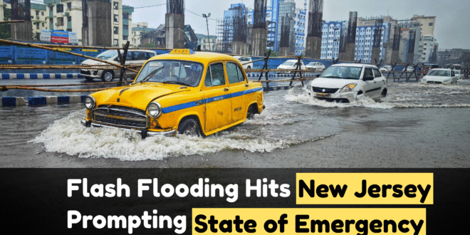
flash flooding On Monday, July 15, 2025, parts of New Jersey were hit by intense flash flooding caused by torrential rains, prompting Governor Phil Murphy to declare a state of emergency. Heavy storms swept across the U.S. Northeast, impacting areas including Essex, Union, and Somerset counties, along with nearby regions in New York City. The National Weather Service issued multiple flash flood warnings, citing extreme rainfall rates and overwhelmed drainage systems.
Record Rainfall and Flooding Impact
In just a few hours, over 6 inches of rain fell in some locations, overwhelming storm drains and triggering urban flooding. In parts of Newark and Elizabeth, roads turned into rivers, submerging vehicles and damaging property. New York City experienced similar conditions, with subway stations flooding and sidewalks submerged. In Manhattan, two inches of rain fell in less than 30 minutes, flooding major intersections and residential streets.
The intensity and speed of the storm left little time for preparation, making conditions dangerous for residents and travelers alike.
Transportation Disruptions and Water Rescues
The flash floods led to major transportation chaos. Several highways, including portions of I-95 and Route 22, became impassable. Public transit was heavily disrupted, with New York City subway lines 1, 2, and 3 suspended or delayed due to flooding in tunnels. Bus services in New Jersey were either rerouted or canceled.
Emergency services conducted multiple water rescues in both New Jersey and New York. In Union County, rescue teams pulled stranded drivers from submerged cars. At Newark Airport and LaGuardia, incoming flights were delayed or grounded due to runway flooding.
Government Response and Public Safety Measures
Governor Phil Murphy’s state of emergency declaration allows the mobilization of emergency resources, including the National Guard if needed. Residents were advised to avoid travel unless absolutely necessary and to stay away from flooded roadways.
“Please do not attempt to drive or walk through flooded areas,” Governor Murphy posted on X (formerly Twitter). “Your safety is our top priority.”
Local officials opened emergency shelters in affected areas, and utility companies were put on alert for possible outages. The state’s Office of Emergency Management is closely coordinating with FEMA and local municipalities to assess damage and support recovery.
Experts Link Events to Climate Change
Meteorologists described the storm system as a “perfect setup” for flash flooding—caused by a moisture-rich atmosphere colliding with a stationary front. Experts pointed out that such extreme rainfall events are becoming more frequent, attributing this pattern to global climate change.
“The warming atmosphere holds more moisture,” noted climate scientist Daniel Schwarz. “When it rains, it pours—and this is exactly what we saw in New Jersey.”
What Residents Should Do Now
-
Stay informed via weather alerts from the National Weather Service.
-
Avoid travel, especially in low-lying areas.
-
Check in on vulnerable neighbors, especially the elderly.
-
Document any damages for insurance and FEMA relief.
-
Follow official guidance for emergency shelter or evacuation, if needed.
New Jersey is now assessing the full scale of the damage, and more rain is expected later this week. Authorities continue to monitor the situation and urge residents to prioritize safety.