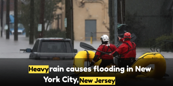
Torrential Rain Triggers Widespread Flash Flooding
On Thursday, July 31, 2025, a powerful cold front swept into the East Coast, dumping heavy summer rain across New York City and New Jersey. Rainfall rates peaked at 2 inches per hour, with localized totals exceeding 5 inches in some neighborhoods. The intense storms prompted the National Weather Service to issue flash flood warnings throughout the I‑95 corridor stretching from Washington, D.C., to New York. State and local officials in both NY and NJ responded swiftly with states of emergency, mobilizing resources, urging residents to stay home, and deploying emergency crews in advance.
Chaos on Roads, Rail, and Subways
Eyewitnesses reported dramatic rescue scenes as motorists climbed onto car roofs while the FDNY and NYPD responded quickly. Other major highways — including the Long Island Expressway, Cross Island Parkway, FDR Drive, and roads in Staten Island — were shut down as flash floods made travel dangerous or impossible. Transit systems suffered too. Firefighters evacuated passengers using ladders after approximately two hours.
Airports, Amtrak, and Regions Disrupted
Amtrak suspended service between Philadelphia and Wilmington. However, tracks reopened after roughly two hours with expected residual delays. Across Pennsylvania and Maryland, flash floods also struck. In Reading, PA, roads were submerged; near Baltimore, emergency vehicles performed rescues and preemptively closed flood‑prone routes. In Mount Airy, Maryland, a tragic drowning occurred when someone was swept into a storm drain — first responders confirmed one death.
Government Response and Ongoing Warnings
New York’s Governor Kathy Hochul and New York City’s Mayor Eric Adams urged caution, warning basement‑dwelling residents to move to higher ground, and recommended early dismissal by employers ahead of evening rush hour. In New Jersey, Acting Governor Tahesha Way similarly issued public advisories and declared a statewide emergency as rainfall warnings covered the state.
FAQs
Q: When did this severe flooding event occur?
A: The flash flooding and state of emergency began on Thursday, July 31, 2025, with rainfall continuing into the evening and flash flood watches extending into Friday, August 1, 2025, afternoon.
Q: How much rain fell in the hardest‑hit areas?
A: Rainfall totals ranged from 1–3 inches broadly, with isolated areas—especially in Queens, Long Island, and southern New Jersey—receiving up to 5 to 8 inches of rain.
Q: Were there any fatalities or injuries?
A: One fatality was confirmed in Mount Airy, Maryland, where a person was trapped in storm drain waters. In New York City and New Jersey, all individuals trapped in submerged vehicles and trains were rescued safely with no reported injuries.